


Nature
Oki Islands UNESCO Global Geopark 隠岐ユネスコ世界ジオパーク


UNESCO Global Geopark rising out of the Sea of Japan
The Oki Islands UNESCO Global Geopark is famous for its stunning seascapes and breathtaking coastal scenery, making this geopark a top choice for tourists.
Global Geoparks are geographical areas where sites and landscapes of international geological significance are managed with a holistic concept of protection, education and sustainable development, and the Oki Islands Geopark fits that description perfectly.
Don't Miss
- A sunset cruise to Rosoku-jima (Candle Island)
- 257-meter-tall Matengai Cliff
- A 360-degree panorama of the islands from Mt. Akahage
How to Get There
The Oki Islands UNESCO Global Geopark is best reached by ferry.
Car ferries to the Geopark depart from Shichirui Port near Matsue in Shimane Prefecture and Sakaiminato Port near Yonago in Tottori Prefecture ![]()
![]() . The journey takes between two and a half hours and four hours depending on which island you go to. Both ports also operate a high-speed hydrofoil service for passengers only.
. The journey takes between two and a half hours and four hours depending on which island you go to. Both ports also operate a high-speed hydrofoil service for passengers only.
Oki Aiport on Dogo has flights from Osaka that take 50 minutes and from Izumo Airport in 30 minutes.
A car ferry service connects Dogo and Dozen islands, and a smaller ferry service connects the three islands near Dozen. Buses are available on each island, but are infrequent. Some people prefer cycling, but renting a car is the most convenient way to see the sights.
Geopark Visitor Center
A good place to start is the Geopark Visitor Center located next to the main ferry terminal in Saigo Port on Dogo, the largest island. Here you can pick up all the maps and brochures you need. The staff in the Tourism Information Office on the ground floor of the building can help with suggested itineraries or arranging assistance. A variety of bicycles is available for rental from here. Next to the Tourism Information is the Oki Islands Geopark Promotion Committee, a small library corner, coin lockers and resting area. On the second floor is the Oki Islands Geopark Museum, featuring a comprehensive exhibition about the nature, culture and history of the Oki Islands. All information panels provide information in English. At the dozens of sites of interest around the islands there are large information boards in both English and Japanese with diagrams, photos, and easy explanations about what you can see.
There are four inhabited islands in the archipelago. The largest is Dogo, which is roughly circular with the center rising to 607 meters. The three other islands, Nakanoshima, Nishinoshima, and Chiburijima, are collectively known as Dozen, and are the remains of a sunken caldera and are individually convoluted in shape but roughly circular as a group.
Highlights of Dogo
There are plenty of sites to see in these islands. At the far northern tip of Dogo is the Shirashima Coast, a cape with viewpoints 200 meters above the sea looking out at a series of islands capped with green vegetation rising out of the blue sea.
About a 20-minute drive from the Shirashima Observatory is the Jodogaura Coast. The rocks here were formed by volcanic activity 26 million years ago when the area was still connected to the mainland. You can see a delightful collection of small coves with islets, rocky beaches, cliffs, and rock formations.
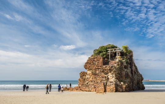
On the northwest coast is Candle Island, an icon of Dogo Island. You can view this spire of rock rising from the sea from the viewpoint at Ojirobana,but unless you take the sunset boat cruise, it does not look like a candle lit at the tip of the rock at sunset.
Highlights of the other islands
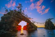
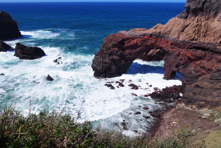
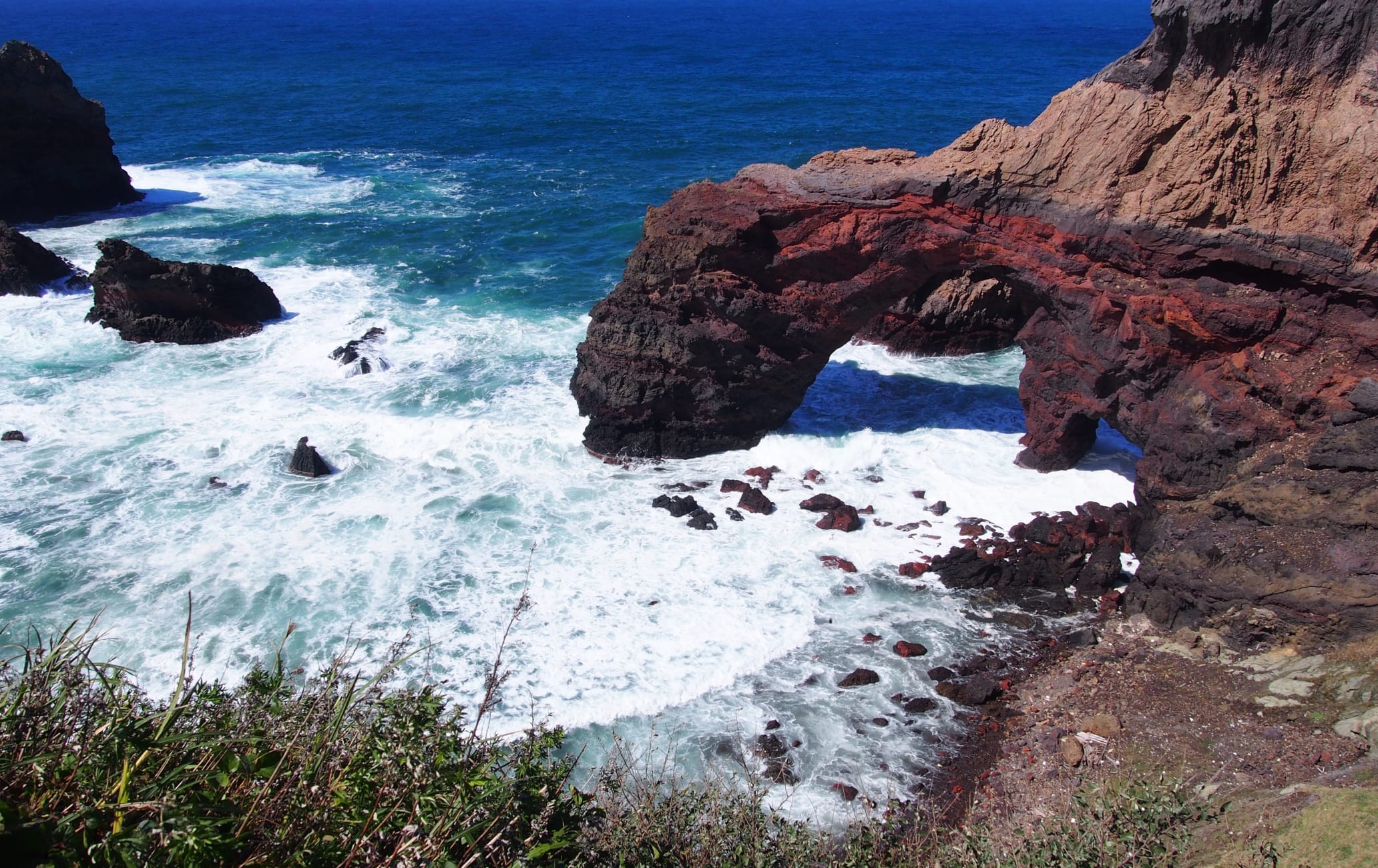
On Nishinoshima you can explore the Kuniga Coast with its natural arch and sculpted rock formations. The nearby Matengai Cliff rises 257 meters above the sea, among the tallest in all of Japan, and is best seen from a scenic boat tour. Don't miss Mt Takuhi, the central cone of the sunken caldera. An old shrine is nestled on its slopes, and from the top there are great views in all directions.
Mt Kinkoji, over on Nakanoshima, while not as high as the 452-meter Mt Takuhi, offers stunning views over the vast flatland characteristic for this island, with Nishinoshima Island in the background. The Akiya Coast in the north of the island features red rock cliffs and a heart-shaped opening in one of the rocks. There is a rocky beach and campsite here.
Over on Chiburijima, the smallest of the inhabited Oki Islands, you can see the red cliffs at Sekiheki, but here the cliffs have vertical stripes that alternate between black, white and other colors. The highest peak of the island, Mt. Akahage, provides an impressive 360 degree view of the all Oki Islands and, on a clear day, even the Shimane Peninsula and Mt .Daisen in Tottori Prefecture.
From the cliffs, beaches, coves, and mountains as well as from out at sea there is a fantastic variety of amazing coastal landscapes to see in the relatively small area of the Oki Islands.
* The information on this page may be subject to change due to COVID-19.
Recommended for You